Rho Earth LC · Forest Risk Intelligence Platform
See which forests will survive and which are already on a path toward loss
ForestCast forecasts tree mortality, stress accumulation, storm damage, and post-disturbance recovery across 766 million acres of U.S. forestland -- giving land managers, agencies, and stakeholders the lead time to act.
One platform, every stakeholder in forest health
Forest risk touches federal agencies, state programs, landowners, and the financial sector. ForestCast delivers decision-grade intelligence tailored to each. See the decisions we support →
Federal & State Agencies
For USFS scientists, state forestry programs, and extension services. Continuous monitoring between FIA cycles, forward-looking pest risk, post-disturbance triage, and decision support for budget and policy.
Timber & Forest Owners
For timber companies, TIMOs, REITs, and large landowners. Stand-level forecasts, salvage decision support, portfolio risk concentration, and the kind of analysis your board and investors will trust.
Insurance & Finance
For underwriters, financial institutions, and carbon markets. Forward-looking risk that historical loss tables can't capture, portfolio-level exposure analysis, and quantified carbon permanence.
Forests are dying on a timeline no one is tracking
Hurricanes, drought, bark beetles, fire, and compound heat events are reshaping America's forests faster than monitoring systems can follow. But the most dangerous losses are not visible the week after a storm.
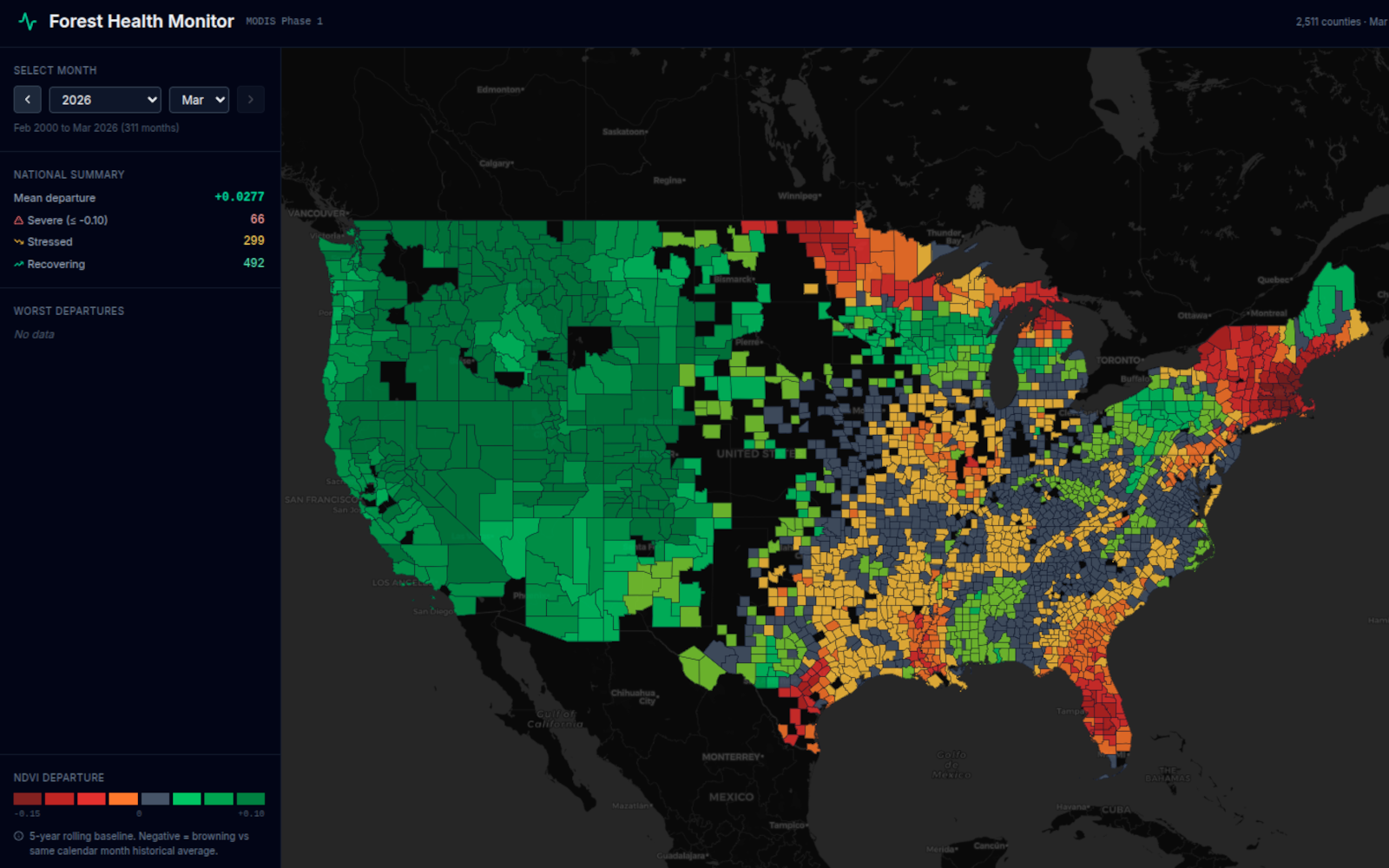
Delayed mortality -- the long tail of tree death that unfolds months to years after disturbance -- is the dominant mode of forest loss in many regions. A stand that looks green from orbit may already carry lethal stress loads.
Current monitoring was designed for a slower world. FIA remeasurement cycles span years. Aerial surveys are annual snapshots. Neither tracks how compound stressors interact and accumulate.
Three capabilities, one system
ForestCast connects monitoring, forecasting, and scenario modeling for operational decisions at every scale. See platform details →
Monitor
While others show you what's visible, ForestCast reveals the hidden physiological state of every stand -- stress, reserves, and structural change beneath the canopy.
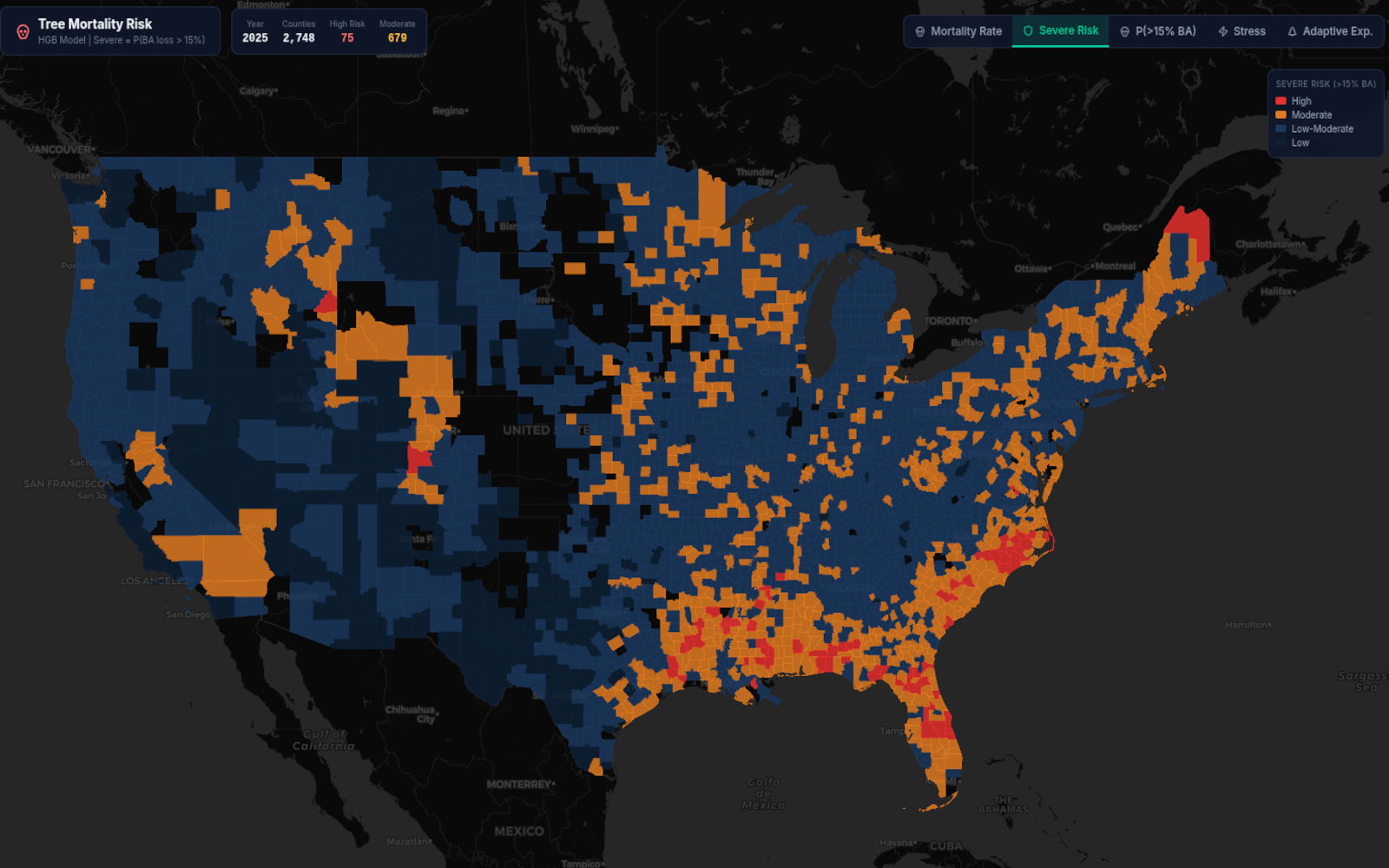
Forecast
Probabilistic forecasts across the full spectrum of biotic and abiotic threats: bark beetles, drought, wind, fire, and the compound interactions that drive delayed mortality.
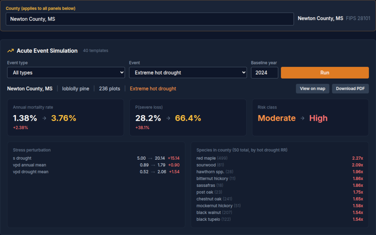
Scenario Engine
Understand your choices before you act. Compare management strategies, explore what-if scenarios, and act with confidence when the stakes are highest.
From the field
Forest Actuarial System Goes Live
ForestCast's stand-level actuarial module is producing forward-looking mortality risk pricing for insurance and financial workflows. Probabilistic loss projections at the stand and portfolio level, designed to integrate with reserving and underwriting processes.
Drought Naivety Hypothesis Validated
Adaptive exposure features outperform absolute stress metrics by a factor of four for explaining mortality variance under novel drought conditions.
National Monitoring Archive
Multi-tier monitoring across four satellite platforms covering all 3.24 million forested hex cells in the continental United States.
Let's talk about forest intelligence
Whether you manage national forests, run a state program, advise landowners, underwrite timber risk, or build the tools and platforms that serve these communities -- we would like to hear from you.